Health & Fitness
Why Do We Call It Briones, Franklin Canyon, Raap Avenue.....?
Where the Names We Call Places Come From --- Bill Mero Decided to Find the Answers
County Place Names We Take For Granted…
Nearly 50 years ago I picked up a fascinating book entitled “Names on the Land”. It traces the history of how place names appeared on everything in the United States from natural features to towns, cities, counties and states -- sometimes on purpose and quite often by accident or misunderstanding or the last voice being the loudest voice.
Written by UC English professor George R. Stewart in 1944, it is easy to find online. Among the interesting facts are that Springfield and Greenville are among the most common town names across the country and that the Connecticut River’s name came from the English settlers asking one Indian tribe for the name then transferring it from phonetic to written word.
Find out what's happening in Martinezwith free, real-time updates from Patch.
What the Europeans did not realize until later was that each tribe had no concept of the river having one name for its entire length or even a concept of what that total length might be – each had its own name for the segment that they lived on. Consequently many rivers and lakes we know now by what was originally a “neighborhood name”.
Then there’s California, named after Queen Calafia, a mythical figure in a conquistador’s wishful thinking dream of an island off the coast of Mexico covered with pearls and gold etc. What eager explorers actually found was the desert tip of what we now call Baja California --- after the queen who never was but a form of whose imaginary name is now what we call home.
Find out what's happening in Martinezwith free, real-time updates from Patch.
Local historian and longtime County Historical Society volunteer Bill Mero decided to research the origins of Contra Costa County place names for a book he calls “Shadow on the Hills: Place Names of Contra Costa County”. (2011 - $19.95- available at Contra Costa County History Center, 610 Main St., Martinez, CA 94553). While the local names Mero researched are not so fanciful as “California”, their origins are interesting.
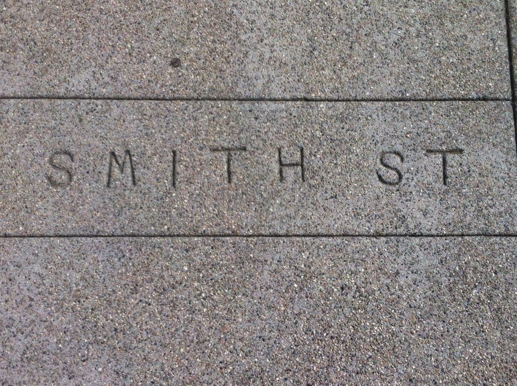
Noting that current names we all take for granted actually represent everyone in the County’s past from Indians to scalp collectors, grizzly hunters not to mention the grizzlies themselves, coal kings, cattle ranchers and wheat barons as well as electric railway stations, a powder factory and a beautiful Moorish castle in Spain, Mero also shows the changes made over the years. Two local examples are Smith Street who the town’s founder named after himself but for the past 80 years has been officially Alhambra Avenue. Alhambra, the name of creek, avenue, high school and popular bottled water, itself was originally given to the creek as Arroyo del Hambre – valley of hunger – by the Mexican troops allegedly chasing some Indian bandits. Louisiana Strenzel decided hunger did not fit the experience she and her family had raising fruit and wheat in what was a bountifully successful ranch in a beautiful valley so she successfully campaigned to change the name of the creek and hence everything else sharing its name to Alhambra from Washington Irving’s early 19th century book about the beautiful Moorish palace in Spain.
And although I am focusing on Martinez place names at the moment, some of you who remember the flap a year or to ago over changing the name of Mt. Diablo to Mt. Reagan because of the current name’s reference to the Devil will be interested to know that this is not the first time there’s been a controversy about it. In fact, there’s been 5 different names for the local landmark including Coal Hill.
But what about Franklin Canyon, Briones, Bear Creek, Reliez Valley Road, Morello Avenue and Raap Avenue to name a few of the Martinez place names we take for granted?
Franklin Canyon is the name attached to the canyon (and the ridge of hills from the Canyon to Carquinez Strait) through which the original paved road from Martinez to Richmond was built in 1921. In 1853 Edward Franklin bought the 1849 adobe built by Vincente J. Martinez and commonly known as the Franklin Canyon Adobe. For some locations having owned a farm there once secures your name pride of place on the map forever.
If you drive through Franklin Canyon you will see a road sign on the west side – McHarry Ranch Road. Early pioneer James McHarry was born in Ireland in 1830, crossed the plains to California in 1853 and moved to California in 1856 where he eventually owned a successful cattle and fruit ranch in the hills above Franklin Canyon. His descendant, Arthur McHarry, was a well known Main Street businessman and co-owner of Reed’s Stationery Store for many years.
I’ve always wondered who Morello (Avenue, Court, Heights Circle, Park School) was to leave his name so prominently in the southeastern portion of the city. Mero discovered that Morello was a famous local race horse who won both the Futurity Stakes and the Chicago Derby in the late 19th century. The horse died from paralysis at the J. O. Rees Ranch on November 29, 1896. I am adding that nugget to my bucket list of items to find out more about.
I used Bear Creek Road often as a commuter to Hayward as it took the same amount of time in the morning to get from downtown Martinez to Highway 24 just before the tunnel but was a much more pleasant drive. Now I would know that the road I turned left onto from Alhambra Valley Road was originally known as Arroyo de Galindo after one of the founders of Concord. It became Bear Creek Road when the creek became locally more prominent because of the grizzly bears that were “thick as fleas” in the East Bay hills. Early ranchers frequently suffered the loss of pigs, oxen and cattle killed by the bears foraging around Bear Creek. Now most of the creek is below the water of Briones Reservoir.
Briones Regional Park is one of many lasting gifts to the East Bay and Contra Costa County through the skill and vision of the late Hulet Hornbeck who not only convinced the voters of Contra Costa County to vote to join the East Bay Regional Park District but led the District’s outstanding land acquisition efforts for many years leaving a legacy that includes purchase of the Martinez Regional Shoreline and the funds to acquire the Franklin Ridge. Briones’ official address is on Reliez Valley Road in Martinez and its various staging areas are located in Lafayette, Orinda and other central county locations.
According to Mero, the Park might have been named on longtime Martinez Fire Chief, John “Toddy” Briones but no mention is made of him in the official Briones park brochure. Instead, the site is described as being a major portion of the Rancho Boca de la Canada del Pinole (rancho at the mouth of the Pinole Canyon). In 1829, Felipe Briones built a home near what is now the Bear Creek entrance to the park. After he was killed in 1840 near Clayton by Indians, his widow petitioned for a grant to the three square miles of land the family had occupied raising cattle. It was given in 1842 and upheld by the U. S. Supreme Court in 1860. Soon after Martinez businessmen Simon and Elias Blum bought most of the property. In 1906, the People’s Water Company began purchasing land around Bear Creek for watershed – most of it owned by the Blum family and the Brown Ranch. The East Bay Municipal Utility District acquired People’s Water Company in 1916 and constructed the San Pablo dam in 1923.
Another locally favorite shortcut to Hwy 24 is Alhambra Valley Road to the ‘t’ with a left turn onto Reliez Valley Road which winds through southern Martinez, Pleasant Hill and Lafayette before intersecting with Pleasant Hill Road just north of Acalanes High School and the onramps to Highway 24. The road also parallels a creek which first appears on 1869 maps as Raliez Creek. The United States Geologic Survey maps of the early 20th century name it Reesley creek and valley. Mero suspects Reliez, Raliez and Reesley may be an English corruption of a Spanish word for the landslides that were fairly common in the area (“vease” or “deliz”).
Just one more for now….Raap Avenue, a block west of what is now Les Schwab Tires on Alhambra Avenue, is named for Henry Raap who bought a 200 acre farm one mile south of Martinez in 1863. He was born in Germany in 1830. He came to California by the shortest but most dangerous route across the Isthmus of Panama 60 years before the Panama Canal opened. In 1854, the tortuous crossing exposed travelers to the dreaded and often fatal yellow fever. Raap headed for the Sierra gold mines and then travelled around a fair amount before settling here. He was one of the founding members of Alhambra Grange and the Grangers Business and Warehousing Association in the 1870s.
To find out more about Martinez and Contra Costa County history:
– 1005 Escobar Street, cnr of Court Street
Open Tues and Thurs 11:30 a.m. to 3p.m. First 4 Sundays 1-4 p.m. Tel: 925-228-8160; www.martinezhistory.org
– 610 Main Street, Martinez
Open Tues through Thurs, 9 a.m. to 4 p.m.; 3rd Saturdays, 10 a.m. to 2 p.m. Tel: 925-229-1042; www.cocohistory.com
On display through June 28, 2012 at the County History Center, 630 Main Street, Martinez (Tues, Wed, Thurs, 9 a.m. to 4 p.m. and third Saturdays, 10 a.m. to 2 p.m.): Before BART: Electric Railroads in Contra Costa County.