Community Corner
Walk About Martinez -- Volcanos and Labyrinths
A visit to Sibley Volcanic Regional Preserve and we find labyrinths, this week in Walk About Martinez.


The view from the promontory took in all the Bay. San Francisco dazzled in the morning light. Both the old and new spans of the bridge from Oakland bent their way to Yerba Buena Island and the Golden Gate Bridge draped the mouth of the estuary like a Hollywood dresser had been at work. Light shimmered over the water to the south at the foot of the Santa Cruz Mountains and the sleeping Indian princess, Mount Tamalpais, lay dozing as always on the horizon above Marin. The view from the Oakland/Berkeley Hills has got to be one of the most beautiful cityscapes in the world.
We stayed only a moment before the freezing wind chased us back into a sheltered hollow on the heights. We were in an extinct volcano that straddles the hills just above the Caldecott Tunnel. The ten million year old volcanic core has been uplifted and laid on its side by the tremendous tectonic forces that formed the Berkeley Hills. Then the whole area was quarried for rock turning it into a jumble of roads and pits and promontories, creating a wonderland of overgrown, mixed up landscapes. It would have been a terrible eyesore 80 years ago, but the final chapter for this old hot spot happened in 1936 when it became, Round Top, now Robert Sibley Volcanic Regional Preserve, one of the first 3 parks created by the East Bay Regional Park District along with Tilden and Temescal.
Find out what's happening in Martinezwith free, real-time updates from Patch.
Robert Sibley was one of the founders of the EBRPD, and served as its Board Chairman from 1948 to 1958. Parks advocate that he was, the Great Depression didn’t slow him down and he helped organize the first mass public meeting in Oct 1931, where over a thousand people showed up and signed petitions asking for the Water District to cede excess lands for public recreation. Well, for the firestorm he helped create and the first in the nation, Regional Park District it gave birth to, a volcanic preserve is probably apropos.
On a cold, clear, windy day last week, our hike began on the Contra Costa Side of the Berkeley hills. The trailhead is at the end of Old Tunnel Road, just off Fish Ranch Road. One turn up the canyon to the south of the Caldecott Tunnel and all the rush and traffic of Highway 680 seem gone from the world.
Find out what's happening in Martinezwith free, real-time updates from Patch.
It was quiet and calm as I started up the Old Quarry Road with Brad and Linda and John, all regulars when it comes to a good walk. The road was paved for the first half mile or so and we followed uphill to the ridge and our first quarry cut through the volcano. Here, a thick lava flow had been covered by a layer of tuff -- volcanic ash and cinder -- which had subsequently been baked red and compressed by another lava flow. Then the whole thing had been thrust on end by the geologic forces at work in these hills. The result was a magnificent cross cut into the ancient life of the volcano. High in silica, these flows -- at times over 150 feet thick -- would have moved slowly at walking speed across the land, burying and burning all in their path. It would have been a spectacular sight.
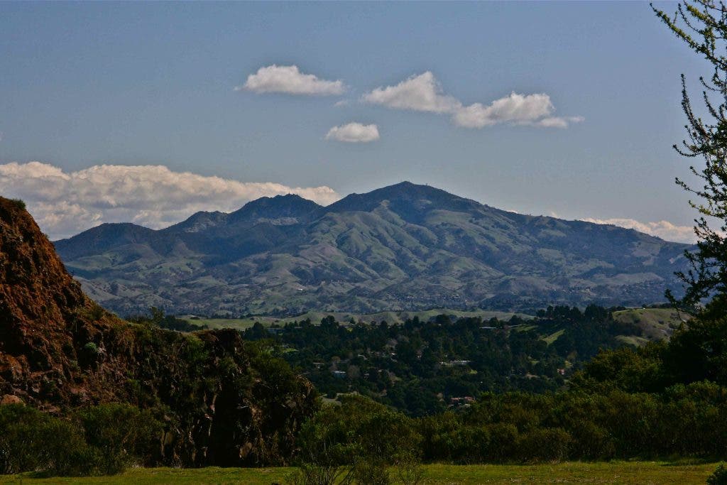
We continued through the cut and came out onto a view of Mt. Diablo, towering above the Orinda and Moraga Hills. Framed by red volcanic rock on the left and a thick forest on the right, it was simply stunning.
We didn’t really care where we were going -- I’m always content with any walk -- we followed a path down hill to an old quarry site, which was thick in new grass. The trail led into a deep forest and up hill. Although I was in the lead, I wasn’t really leading, just wandering across the landscape. Well, we ended scrambling steeply up through some thick chaparral with nothing to show for it but a good winding, and my lame excuse at not really knowing where we were going, when we came out at the top of the hill and were greeted by a view of San Francisco Bay that took our breath away.
Seeing the City in all its magnificence, the coastal mountains and the beauty of the Bay from that promontory led me to just imagine what Juan Portola must have experienced when he crested Sweeney Ridge on the San Francisco Peninsula in late October 1769 and first laid eyes on the richest natural bay in North America. It was home to vast herds of tule elk and deer, migratory birds by the millions and an unrivaled inland fishery. In his accounts of the expedition, Father Crespi wrote that not only the Spanish Navy, but all the navies of Europe could take shelter in it. It’s still a marvel, especially seen from a great height.
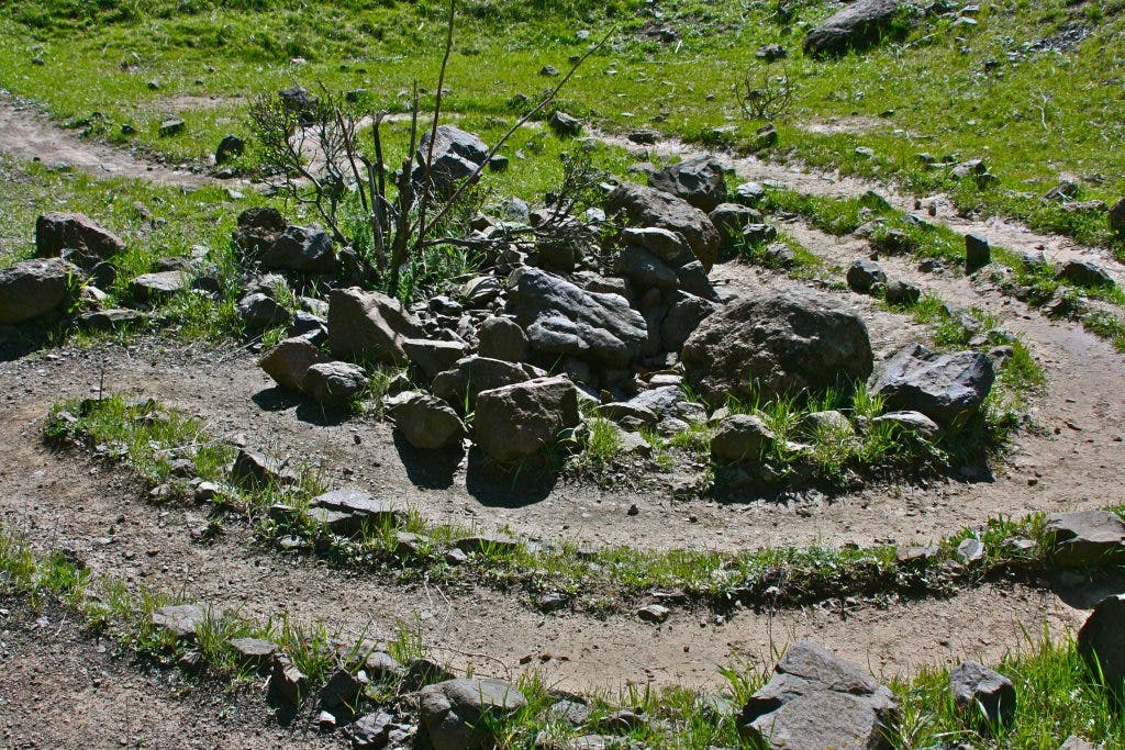
We followed trails and old dirt roads southeast along the ridge and before long came upon an old quarry site in which someone had created a rock lined labyrinth, patterned on neolithic labyrinths in Europe. Found in many cultures across the world, labyrinths are always sacred. In the heart of this old volcano, in the bottoms of the old quarries, a number of them have been built. Many people in the Bay Area think of the Round Top Volcano as a power spot, and stories abound of midnight rites performed up here. Be aware that the park is only open till 10pm, March to October. But the stories persist.
Hiking still further we came upon the largest of the quarry sites, a huge pit where the quarry men have opened the very heart of the volcano. Here, the geology lies right before your eyes and in the center of the pit is the largest labyrinth in the park. Tuff-breccias -- a mix of ash and chunks of volcanic rock -- lie below. The wall ahead is made up of the lava that once capped the crater which was originally only a little wider than the quarry pit itself.
We had lunch by the side of the labyrinth, the pit giving us respite from the bitter wind and cold, and then headed back down to the parking lot much warmer in the shelter of the canyon trail. Scotch broom, a terrible invasive nonnative and the scourge of all our local coastal parks, was blooming in all its impossibly yellow glory, and at least for now, I had to put aside my usual disdain. Linda had a pedometer and measured our hike at just under four miles.
I like the Contra Costa entrance to this park because it offers a good climb to the ridge, but the main entrance lies along Skyline Boulevard in Oakland. It’s not much further to drive to this trailhead, and the self guided nature hike and trail numbers in the park brochure begin from the Oakland entrance. Best of all for many is that the hike is almost level from this trailhead as you’ve already driven to the ridge. This park is very popular with dog walkers, but check for ticks on your dog and yourself after a visit this time of year.
In a short documentary for Quest, KQED’s multimedia series, Steve Edwards, the director of the EBRPD Botanic Gardens, and the author of the Sibley brochure, describes the park as an outdoor laboratory in Coastal Range geology. Because the core is laying on its side, and has been split open by the Kaiser gravel mining, the volcanic intrusion into the sedimentary layers is uniquely visible here. It’s well done and a fascinating introduction to the park.
If you visit Sibley, make sure you pick up a park brochure when you start your hike as the self guided tour will explain a lot about what you’re walking over. And if you want to get a little beyond the science, stop for a quiet few minutes and walk a labyrinth.
“By forces seemingly antagonistic and destructive Nature accomplishes her beneficent designs - now a flood of fire, now a flood of ice, now a flood of water; and again in the fullness of time an outburst of organic life....” John Muir
