Community Corner
Walk About Martinez
A hike up Shepherd's Canyon, the Little Engine that could, and a tribute to Kathy, this week in Walk About Martinez.


Well, we’re back to winter with a vengeance and it’s pouring rain as I type. But last week, when I walked with friends into the Franklin Hills, the sky was clear as far as you could see. The temp was in the upper 70s. That kind of warmth in the middle of February is the reason I think I’ll stay right here in the Bay Area. A Mediterranean climate is probably one of the best on the planet. Not quite as soft as the tropics, it's just enough edge to keep it exciting. But it's not the kind of “weather that will kill you” as we used to say about the storms in Texas, and which is completely applicable to the deep freeze most of the nation has been experiencing.
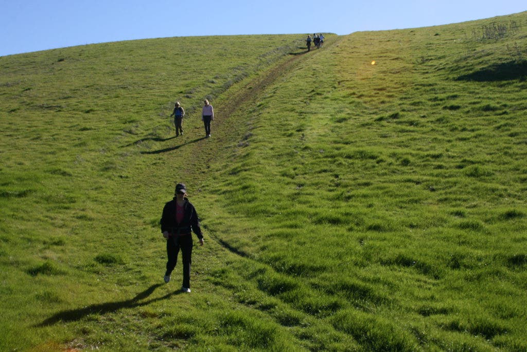
This was weather to get you out of your cozy, winter-warm house and out walking our hills. We had 11 people show up to hike Shepherd’s Canyon, a deeply wooded ravine typical of our oak/bay forests that opens onto the wide grassland expanses on the tops of our ridges. The trails were dry and when they are, this is a hike of moderate strenuousness. They're wet this week, so you can up that level of difficulty to very slippery. Shepherd’s Canyon is the start of a loop trail that wraps around the last large section of bluffs in the Franklin Hills, which fall away sharply to the Carquinez Straits below. You get some great views from up there. On a clear day it’s the snowy Sierra to the east, Diablo to the south, Mount Tamalpais to the west, and the Sutter Buttes and Sugar Loaf to the north.
To get there, drive out Carquinez Scenic Drive and park at the bottom of the canyon, near the end of the road. If you come to a dead end, just turn around and drive a few hundred feet back to a green gate. That’s your entrance. If you hike up and keep following the dirt road to the left, you will complete a loop of about 2.5 miles. The last part of the loop just before you return to the Shepherd’s Canyon Trail is quite steep and I recommend hiking poles for stability.
Find out what's happening in Martinezwith free, real-time updates from Patch.
Some in our party chose to hike the loop, but most of us turned right onto the Hulet Hornbeck Trail, following it south about a mile to climb “Nazi Hill.” The students at Alhambra High think they named it because it’s so steep, and they have to run it, or at least walk up it, as part of their P.E. requirement.
Well, they didn’t name it. During World War II, it was the site of an old Japanese sub spotting tower manned by local Martinez patriots. From its height you could see from San Pablo Bay to Suisun Bay, and a good bit of the river leading inland. The name may be a bit of an anachronism, as the Japanese were not Nazis, just their allies, but it was all the same war. When the parks bought the land, the tower was still standing, although in semi ruin. It was torn down because it was a danger to the public, and all that remains is the name and a very steep climb.
Find out what's happening in Martinezwith free, real-time updates from Patch.
I’m glad to report that several in our party got to the top deep in conversation, and then noticed they were on top. Darryn looked over at me and said, “That was Nazi Hill? That was a piece of cake.” Always hike with a talkative friend if you want to climb a hill without noticing it.
Shepherd’s Canyon is a beautiful hike, but now that the rains have returned, bring hiking poles! It’s hikeable even in all its muddy glory, but it’s really slippery without poles. A map of the area is at: www.ebparks.org/files/Carquinez_Crockett_map_noTopo_2009.pdf.
Trail Stories: How I met Little Engine. Therein lies a tale, or at least a crazy coincidence.
In early April 2010, three days before I set out for Campo, the little town almost on the Mexican border from which the Pacific Crest Trail begins, I called my cousin Barb in Seattle to let her know I’d be hiking the PCT, and might be in Washington toward the end of the summer. She stammered a bit and then told me that as we spoke, she was making a salad for a potluck going-away party for a good friend’s daughter, Katie, and her boyfriend, Adam. They were just about to embark upon the same trail, and a thru hike to Canada. Katie was Barb’s daughter’s best friend growing up in Seattle.
I put their names in my ol’ memory bank, and a brief description, and figured I probably wouldn’t ever meet them on a trail that was several thousand miles long. Barb said she’d pass my name on to them and we both marveled at the coincidence.
By late April I had made it to Idyllwild, on the west slopes of the San Jacinto Mountains just east of Palm Springs. The deserts had been cold and I’d been snowed and rained on, and hadn’t seen any desertlike heat to speak of. The San Jacintos are over 9,000 feet, and were still deep in snow.
The day I got to Idyllwild, the local search-and-rescue teams had just completed their first chopper airlift rescue of a hiker who had slipped on Apache Peak and been unable to self-arrest with his ice axe. He hadn’t been killed, but the SAR team was asking us to hike around the mountain on the park roads and to stay off the PCT. Somewhat earlier, another hiker had slipped without an ice axe and had attempted to self-arrest with his pocket knife. He stopped his slide, but only at the cost of severe cuts to his hands.
The town was festooned with banners welcoming the PCT hikers, and we were filling up the local campgrounds, cabins and resorts fast because people simply didn’t know what to do. Wait and let it melt off? That might take weeks or even longer. Hike around? That meant losing some of the great desert mountain views. Jump forward around the mountains to the Mojave Desert and hike that first? This meant breaking up the continuity of what everyone hopes will be a start to finish thru hike. Or just ignore the SAR team and hike the PCT over the mountains in spite of the snow.
I went to the Post Office to get a resupply box mailed by my wonderful wife, and then to the pizza parlor, the most popular hiker hangout in town. A small group of "20-something" hikers were talking outside and one of them was addressed as Adam. I looked at them and said, “Are you Adam and are you Katie?” To which she replied, “Are you Scott?”
Well, that's who we were, and a friendship was born at that moment that took us from the southernmost deserts to the High Sierra, the Trinity Alps, the Marble Mountains, the Siskiyous and the Cascades, all the way to Mount Hood. We easily hiked 1,800 miles together as dear friends, comrades and life support. We pulled each other up treacherous cornices and linked arms forming human chains through the swollen rivers of the Sierra. The adventures I had with those two went on for months.
Katie, whose trail name is Little Engine, because she really “could!” was blonde, slim as a rail and, like so many on the trail, strong as an ox. She and her guy, Adam from Long Island, who eventually became Plain Slice, are two of the finest hikers I’ve ever spent time with on the trail.
One of the other lovely coincidences was that Little Engine was of Swedish descent, as am I, and Plain Slice is Jewish and from New York, as is my wife. The daily sharing, comparing and exploring of our similar couples experience was a great joy on the trail. They remain two of my favorite hiking companions, and we may hike a section of the John Muir Trail again this summer as Katie is just about to enter grad school and needs to take advantage of this last free summer.
Somewhere up trail we told this story, talking about the wild coincidence of meeting on a trail that was more than 2,600 miles long. The hiker paused, but without missing a beat said, “Yah, but it’s a really narrow trail.” I guess that goes for many of the coincidental occurrences we all have.
Tribute to Kathy: Many of you know of the passing last week of Kathy Radke, but if you don’t and didn’t know her, we lost a great lover of wilderness, and beauty, and people. As I write, the pouring rain outside seems fitting, as if the sky itself were joining in with its own burst of sorrow.
She was beautifully eulogized in the Martinez News Gazette a few days ago, and I have little to add. Her importance to all the environmental initiatives locally was so well told there.
What I do have to add about my friend and neighbor has to do with a backpacking trip she took many years ago on the Appalachian Trail. At this point, I don’t know where she hiked on the AT, or what she experienced, but I remember her coming back with the most marvelous tales of long-distance hiking, and of the thru hikers she had met. Her enthusiasm captured me, and I began looking in on the AT web pages. Eventually I began printing them out, and following people hiking all summer from Georgia to Maine.
This began a secret dream of someday thru hiking myself. So Kathy, I give you my deepest thanks. Thank you for all the wonderful things you did in this town. Thank you for all the friends you helped, the mentoring you gave. Thanks for being a wonderful neighbor. But for me, thanks most of all for planting a seed that eventually grew into the most important adventure of my life.
Thanks, Kathy.
“A few minutes ago every tree was excited, bowing to the roaring storm, waving, swirling, tossing their branches in glorious enthusiasm like worship. But though to the outer ear these trees are now silent, their songs never cease.” John Muir
